Jump to content

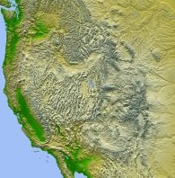
Fasciculus:MAP.USA Relief west.jpg

Page contents not supported in other languages.
E Vicipaedia

MAP.USA_Relief_west.jpg (195 × 198 elementa imaginalia, magnitudo fasciculi: 45 chiliocteti, typus MIME: image/jpeg)

Hic fasciculus apud Vicimedia Communia iacet; in aliis inceptis adhiberi potest. Contenta paginae descriptionis fasciculi subter monstrantur.

Summarium

Descriptio
English: NASA - Jet Propulsion LabPIA03377: Shaded Relief with Height as Color, North America Target Name: Earth

Is a satellite of: Sol (our sun) Mission: Shuttle Radar Topography Mission (SRTM)

Spacecraft: Space Shuttle Endeavour

Instrument: C-Band Interferometric Radar

Product Size: 9600 samples x 7240 lines

Produced By: JPL
Fons NASA
Auctor NASA. Cropped by User:Andrew Dalby

Potestas usoris

Public domain This file is in the public domain in the United States because it was solely created by NASA. NASA copyright policy states that "NASA material is not protected by copyright unless noted". (See Template:PD-USGov, NASA copyright policy page or JPL Image Use Policy.)
Warnings:

Captions

Add a one-line explanation of what this file represents

Items portrayed in this file

depicts Anglica

Historia fasciculi

Presso die vel tempore fasciculum videbis, sicut tunc temporis apparuit.

Dies/TempusMinutioDimensionesUsorSententia
recentissima13:58, 18 Augusti 2016Minutum speculum redactionis 13:58, 18 Augusti 2016 factae195 × 198 (45 chiliocteti)Andrew Dalby== {{int:filedesc}} == {{Information |Description={{en|1=NASA - Jet Propulsion LabPIA03377: Shaded Relief with Height as Color, North America Target Name: Earth Is a satellite of: Sol (our sun) Mission: Shuttle Radar Topography Mission (SRTM) Space...